Naver, Daum, Google Open API
글 수 52

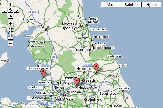
http://www.subkorea.com/api/google/MapsAPI/map-range.html 축소 혹은 확대 이미지 max, min 조정
<!DOCTYPE html PUBLIC "-//W3C//DTD XHTML 1.0 Strict//EN" "http://www.w3.org/TR/xhtml1/DTD/xhtml1-strict.dtd">
<html xmlns="http://www.w3.org/1999/xhtml">
<head>
<title>Google Maps</title>
<script src="http://maps.google.com/maps?file=api&v=2&key=abc...xyz" type="text/javascript"></script>
</head>
<body onunload="GUnload()">
<!-- the div where the map will be displayed -->
<div id="map" style="width: 550px; height: 700px"></div>
<a href="range.htm">Back to the tutorial page</a>
<!-- fail nicely if the browser has no Javascript -->
<noscript><b>JavaScript must be enabled in order for you to use Google Maps.</b>
However, it seems JavaScript is either disabled or not supported by your browser.
To view Google Maps, enable JavaScript by changing your browser options, and then
try again.
</noscript>
<script type="text/javascript">
//<![CDATA[
// Check to see if this browser can run the Google API
if (GBrowserIsCompatible()) {
// A function to create the marker and set up the event window
// Dont try to unroll this function. It has to be here for the function closure
// Each instance of the function preserves the contends of a different instance
// of the "marker" and "html" variables which will be needed later when the event triggers.
function createMarker(point,html) {
var marker = new GMarker(point);
GEvent.addListener(marker, "click", function() {
marker.openInfoWindowHtml(html);
});
return marker;
}
// Display the map, with some controls and set the initial location
var map = new GMap2(document.getElementById("map"));
// ====== Restricting the range of Zoom Levels =====
// Get the list of map types
var mt = map.getMapTypes();
// Overwrite the getMinimumResolution() and getMaximumResolution() methods
for (var i=0; i<mt.length; i++) {
mt[i].getMinimumResolution = function() {return 7;}
mt[i].getMaximumResolution = function() {return 11;}
}
map.addControl(new GLargeMapControl());
map.addControl(new GMapTypeControl());
map.setCenter(new GLatLng(53.3,-1.6), 7);
// Set up markers with info windows
var point = new GLatLng(53.848964,-3.039463);
var marker = createMarker(point,"<b>Blackpool Community Church<\/b><br>Bispham Community Centre<br>Bispham Road<br>Blackpool")
map.addOverlay(marker);
var point = new GLatLng(51.503894,-3.191303);
var marker = createMarker(point,"<b>Cardiff All Nations Church<\/b><br>Sachville Avenue<br>Cardiff")
map.addOverlay(marker);
var point = new GLatLng(53.642126,-1.800942);
var marker = createMarker(point,"<b>Huddersfield Community Church<\/b><br>New Life Church<br>Jubilee Centre<br>Market Street<br>Huddersfield")
map.addOverlay(marker);
var point = new GLatLng(53.955930,-1.089173);
var marker = createMarker(point,"<b>York King's Church<\/b><br>The Priory Street Centre<br>15 Priory Street<br>York")
map.addOverlay(marker);
// Add a move listener to restrict the bounds range
GEvent.addListener(map, "move", function() {
checkBounds();
});
// The allowed region which the whole map must be within
var allowedBounds = new GLatLngBounds(new GLatLng(49.5,-10), new GLatLng(59,2.6));
// If the map position is out of range, move it back
function checkBounds() {
// Perform the check and return if OK
if (allowedBounds.contains(map.getCenter())) {
return;
}
// It`s not OK, so find the nearest allowed point and move there
var C = map.getCenter();
var X = C.lng();
var Y = C.lat();
var AmaxX = allowedBounds.getNorthEast().lng();
var AmaxY = allowedBounds.getNorthEast().lat();
var AminX = allowedBounds.getSouthWest().lng();
var AminY = allowedBounds.getSouthWest().lat();
if (X < AminX) {X = AminX;}
if (X > AmaxX) {X = AmaxX;}
if (Y < AminY) {Y = AminY;}
if (Y > AmaxY) {Y = AmaxY;}
//alert ("Restricting "+Y+" "+X);
map.setCenter(new GLatLng(Y,X));
}
}
// display a warning if the browser was not compatible
else {
alert("Sorry, the Google Maps API is not compatible with this browser");
}
// This Javascript is based on code provided by the
// Blackpool Community Church Javascript Team
// http://www.commchurch.freeserve.co.uk/
// http://econym.googlepages.com/index.htm
//]]>
</script>
</body>
</html>
http://subkorea.com/xe/84579
(*.225.54.140)
|
||||||||||||||||||||||||||||||||||||||||||||||||||||||||||||||||||||||||||||||||||||||||||||||||||||||||||||||||||||||||||||||||||||||||||||||||||||||||||||||||||||||||||||||||||